
Terry’s Guidebook
Beaches
Cronulla is a beachside suburb located on a peninsula framed by Botany Bay to the north, Bate Bay to the east, Port Hacking to the south, and Gunnamatta Bay to the west. The neighbouring suburb of Woolooware lies to the west of Cronulla, and Burraneer lies to the southwest. The Kurnell peninsula, the site of the first landfall on the eastern coastline made by Lt. (later Captain) James Cook in 1770, is reached by driving northeast out of Cronulla on Captain Cook Drive.
Cronulla is a popular tourist attraction. Cronulla Beach features a long stretch of sand that runs from Boat Harbour to North Cronulla, followed by rock pools and another sandy beach at South Cronulla. The beaches of Cronulla from north to south are: Boat Harbour, Wanda Beach, Elouera Beach, North Cronulla Beach, Cronulla Beach, Blackwoods Beach, Shelly Beach and Oak Park. Local names also apply to various parts of the beach, such as The Alley, between Cronulla Beach and North Cronulla, The Wall, between North Cronulla and Elouera, Midway, between Elouera and Wanda, and Green Hills, to the north of Wanda, Sandshoes, near the mouth of the Port Hacking estuary, Voodoo Reef and The Point. The beaches are popular recreational areas for swimming, surfing, bodyboarding, bodysurfing and other water sports.
Shark Island, just off Cronulla Beach, is a famous surfing and bodyboarding spot, and the site of the annual Shark Island Challenge bodyboarding contest. Gunnamatta Bay provides protected swimming at the baths off Gunnamatta Park. Port Hacking is a popular location for such water sports as waterskiing and wakeboarding.
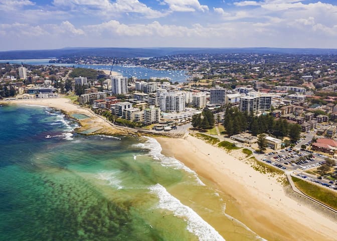
Cronulla
Shopping center
Westfield Miranda - your one-stop hub for shopping, fun & relaxation. Shop a range of fashion, entertainment, dining & wellbeing or check out great events & activities.
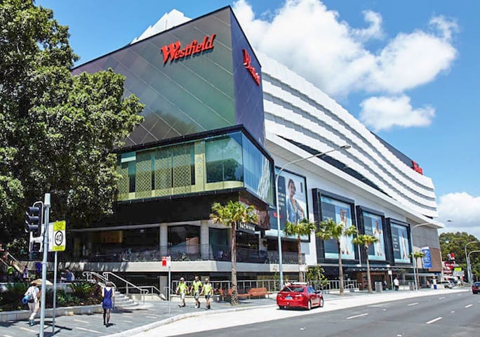
Westfield Miranda
600 KingswayWith in walking distance is Southgate shopping center, It is situated at the intersection of the Princes Highway and Port Hacking Road, which makes Southgate a convenient quality shopping destination.
The Centre is anchored by Coles, Kmart and Woolworths and features 55 specialty stores including Zone Bowling, The Whole Fruit and Grocery Store and First Choice Liquor.
Southgate boasts several high-quality fresh food retailers, a mix of national and boutique fashion, a food court and general retail businesses. Several retail service providers are located at the Centre, including two optometrist, pharmacy, travel agents and an Australia Post outlet.
7 icetyiswa ngabantu basekuhlaleni
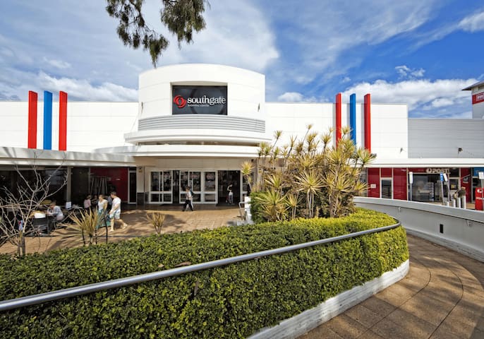
Southgate Shopping Centre
Port Hacking RoadWith in walking distance is Southgate shopping center, It is situated at the intersection of the Princes Highway and Port Hacking Road, which makes Southgate a convenient quality shopping destination.
The Centre is anchored by Coles, Kmart and Woolworths and features 55 specialty stores including Zone Bowling, The Whole Fruit and Grocery Store and First Choice Liquor.
Southgate boasts several high-quality fresh food retailers, a mix of national and boutique fashion, a food court and general retail businesses. Several retail service providers are located at the Centre, including two optometrist, pharmacy, travel agents and an Australia Post outlet.
Sightseeing
Spanning across a whopping 15,000 hectares of pristine bushland and coastline is Australia's oldest National Park, the Royal National Park. From scenic lookouts to secluded beaches to wistful waterfalls, the best way to explore it all is via the many walking trails that wind through the national park.
The Best Royal National Park Walks for Your Weekend Hike
Winifred Falls Trail
For a quick walk, hit the Winifred Falls Trail. The two-kilometre scenic bushwalk of towering gum trees and lush banksia leads to a waterfall at the South West Arm Creek. This picture-perfect spot is ideal for picnics, but if you head another 300-metres downstream to the South West Arm Pool, you can relish in a large natural pool on hot summery days.
Distance: 2 km return.
Time: 1 hour
Otford to Figure 8 Pools
This Royal National Park walk has it all – views, stunning bushland, secluded beach and natural pools. Before you leave, check the tides to make sure they will be low by the time you reach the Figure 8 Pools. Otherwise, you will miss out on the spectacular swimming spot. Start the walk at Otford Station and head to Burning Palms Beach. From there, a steep track will lead you to the Figure 8 Pools. Short on time? Park at Garrawarra Farm Carpark.
Distance: 12km return
Time: 6 hours
Wedding Cake Rock Walk
Forming part of The Coast Track, many opt to just walk the section from Bundeena to the iconic Wedding Cake Rock – a pure white rock formation that stands out against the coastal cliffs' sandstone. What gives it its name is the sharp edges and deep cracks, perched high above the ocean. It's a perfect vantage point for whale watching, and the views up and down the coastline are spectacular. Feeling energetic? Head a little further south to Marley Beach.
Distance: 6km return
Time: 2 hours
The Forest Path
An easy walk that makes you feel worlds away from it all is The Forest Path, which takes hikers through lush rainforest. The walk runs along the Port Hacking River and loops around the green lower gullies of Forest Island, starting and finishing at Sir Bertram Stevens Drive. Perfect for hiking with kids – pack a picnic to sit by Bola Creek or at the Upper Causeway Picnic Area.
Distance: 4.5km circuit
Time: 1.5 hours
Audley park
You can walk beside the river, or cycle along the historic Lady Carrington Drive bor picnic in the flat, grassy parklands. You can also hire a rowing boat from historic Audley Boatshed and paddle upstream where the river curves through the beautiful Royal National Park.
276 icetyiswa ngabantu basekuhlaleni

Royal National Park
Spanning across a whopping 15,000 hectares of pristine bushland and coastline is Australia's oldest National Park, the Royal National Park. From scenic lookouts to secluded beaches to wistful waterfalls, the best way to explore it all is via the many walking trails that wind through the national park.
The Best Royal National Park Walks for Your Weekend Hike
Winifred Falls Trail
For a quick walk, hit the Winifred Falls Trail. The two-kilometre scenic bushwalk of towering gum trees and lush banksia leads to a waterfall at the South West Arm Creek. This picture-perfect spot is ideal for picnics, but if you head another 300-metres downstream to the South West Arm Pool, you can relish in a large natural pool on hot summery days.
Distance: 2 km return.
Time: 1 hour
Otford to Figure 8 Pools
This Royal National Park walk has it all – views, stunning bushland, secluded beach and natural pools. Before you leave, check the tides to make sure they will be low by the time you reach the Figure 8 Pools. Otherwise, you will miss out on the spectacular swimming spot. Start the walk at Otford Station and head to Burning Palms Beach. From there, a steep track will lead you to the Figure 8 Pools. Short on time? Park at Garrawarra Farm Carpark.
Distance: 12km return
Time: 6 hours
Wedding Cake Rock Walk
Forming part of The Coast Track, many opt to just walk the section from Bundeena to the iconic Wedding Cake Rock – a pure white rock formation that stands out against the coastal cliffs' sandstone. What gives it its name is the sharp edges and deep cracks, perched high above the ocean. It's a perfect vantage point for whale watching, and the views up and down the coastline are spectacular. Feeling energetic? Head a little further south to Marley Beach.
Distance: 6km return
Time: 2 hours
The Forest Path
An easy walk that makes you feel worlds away from it all is The Forest Path, which takes hikers through lush rainforest. The walk runs along the Port Hacking River and loops around the green lower gullies of Forest Island, starting and finishing at Sir Bertram Stevens Drive. Perfect for hiking with kids – pack a picnic to sit by Bola Creek or at the Upper Causeway Picnic Area.
Distance: 4.5km circuit
Time: 1.5 hours
Audley park
You can walk beside the river, or cycle along the historic Lady Carrington Drive bor picnic in the flat, grassy parklands. You can also hire a rowing boat from historic Audley Boatshed and paddle upstream where the river curves through the beautiful Royal National Park.
Bike ride to Woolooware Bay
Jump on your bike and ride through Sylvania Waters to Woolooware Bay. using Belgrave Esplanade and Holt Road, continuing to Taren Point and finishing at Woodlands Road. The ramp crossing Captain Cook Bridge links with the Brighton to Homebush regional cycleway and is accessible from Holt Road and Woodlands Road. To the south-east, a cycleway at the end of Parraweena Road in Taren Point provides an off-road link along the Woolooware Bay foreshore to the Solander Playing Fields, onto Captain Cook Drive, Cronulla and Kurnell.
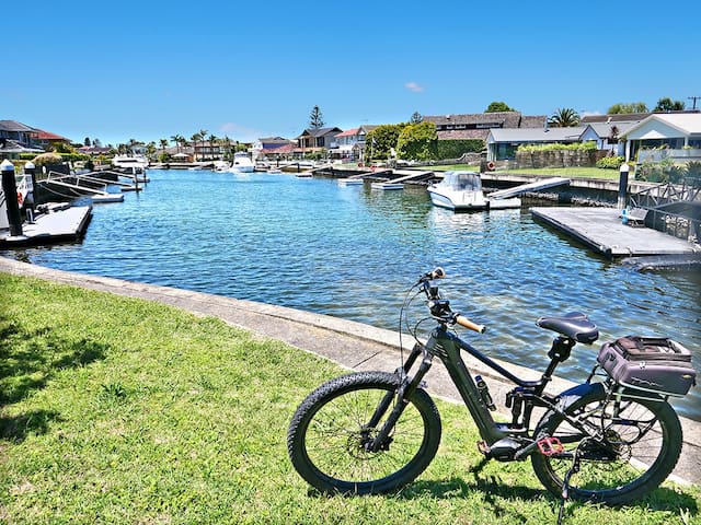
Sylvania Waters